Summary
Pocitos I is an 800 hectare lithium brine project located in the Salar de Pocitos, in the lithium-rich Puna region of northwestern Argentina. The basins in this area produce over 52% of the lithium brine resources in the world.
In August of 2023 Recharge Resource became the uncontested 100% interest owner of the Pocitos 1 project though a direct deal with Ekeko SA.
Recharge is awaiting the completion of the process engineering work, to be completed by Ekosolve Ltd., to produce and assay the lithium chloride being produced, where extraction was above 94 per cent of the contained lithium in the brine.
WSP Australia is waiting on the results of Core Laboratories Australia porosity work to be completed before it delivers the company’s maiden resource estimate at Pocitos 1, that will result in an update of the NI 43-101 report completed by qualified person (QP) Phillip Thomas in June, 2023.
The Puna plateau consists of elevated blocks separated by elongated endorheic (closed) basins, which are contain evaporite deposits. Surrounding mountain ranges have a meridian orientation and their shape responds to uplift in blocks through faults. The Pocitos and Pozuelos basins are separated from each other by the Cordón de Pozuelos. The Cordón de Pozuelos is made up mainly of rocks of Ordovician age, which show slight metamorphism. At the foot of the mountain ranges numerous coalescing alluvial fans can be seen.
The Puna area is bordered on the North by the massif of the Quevar Volcanic Complex (QVC). This is where composite volcanoes unite and form multiple volcanoes. Rounded forms are found, resistant to erosion and, in some areas, such as the Azufre volcano, landslide phenomena are observed. The sedimentary Tertiary deposits are distributed in small outcrops, and they show very low erosion resistance, so they do not form outstanding reliefs.
In the Salar de Pocitos, the main component of the evaporites is halite. The southern portion of the Pocitos salt flat contains accumulations lithium minerals combined with of sodium sulfate and gypsum, the middle region contains part sodium chloride predominates and towards the north manifestations of ulexite (hydrated sodium calcium borate hydroxide) are present. Current clastic deposits correspond to sediments of different origin according to their location with respect to positive reliefs and endorheic basins.
Above 4,500m asl there is evidence of the last glaciation, which is why moraine deposits are found. At lower altitudes, thermoclastism and cryoclastism have generated a large amount of colluvial material that covers the areas of positive relief.
On the slopes surrounding the salt flats, the rivers in the area have formed alluvial fans, most of which are non-functional today. Towards the lower areas, fine sediments predominate, forming the beach environments of the edges of saline bodies. (source)
Naturally flowing lithium brine
2018 Drilling
2018 Drilling
2022 Drilling
History
The Salar Pocitos is a sedimentary intracontinental rift basin that started to accumulate sediments in the Early Cretaceous (Neocomian - 146 to 125 million years ago) era. The basin developed under conditions of extensional tectonic activity and rift-associated volcanism. At present it has sedimentary deposits reaching thicknesses of 5,000m.
The interest for Andean salt pans and their resources began almost a century ago. The first studies were conducted across the Puna de Atacama in northern Chile by geoscientists of the USGS (United States Geological Survey). (Moraga et al 1974)
Argentine government agency, the Direccion General de Fabricaciones Militares (DGFM) completed extensive exploration in the Argentian salars in this region in the 1970s. In 1979, the DGFM reported a reconnaissance sampling campaign at Pocitos that consisted of 12 shallow auger holes and one surface sample. Of the 12 auger holes, two reported anomalous values of 155ppm (Hole P12) and 417ppm Li (Hole P8).
Additional surface sampling campaigns were conducted by Lacus 7 Minerals and Li3 Energy Inc. (Li3E) (OTCBB: LIEG); TEM geophysics by Southern Lithium Corp (CVE:SNL) and Millennial Lithium Corp. in the north-west extreme of the basin and VES surveys by PepinNini Minerals Ltd. (ASX: PNN) on the northwestern and eastern margins of the basin. (source 2018 PepinNini Minerals Annual Report)
Li3E reported in a press release their 2010 shallow sampling campaign and geophysics results. The sampling was near-surface on two 6km x 2km grids, located to the north-east of the Pocitos West properties. The campaign returned values of 100-300ppm Li in the eastern area, and 1-200 ppm Li in the western grid. A resistivity survey over the Li3E prospect area reportedly identified three target areas, including one highly conductive zone of 0.2 ohm-meters at 250 meters deep, and other possible mixed brine zones of 0.4 - 0.75 ohm/m that encase the high conductivity layer from near surface to 450 m. (source August 3, 2017 NI 43-101 Technical Report prepared by Nivaldo Rojas.
Lacus Minerals also reported in 2010 on their sampling and geophysics overseen in the same area, which was later optioned to Li3E. While Lacus did not report geochemical assay values, they included in their report distribution maps for 95 samples collected at 6.8 meters and below indicating values up to 255ppm Li. Their geophysical survey consisted of 42 soundings from which the interpretation indicated a possible 140m thick conductive brine layer with the top at a depth of 150m. According to Lacus, the brine-bearing horizon could be projected to the surface at the western margin of the basin, comprising the western limit of Millennial’s claims and consisting of conglomerate and sandstone. (source NI43-101 Technical report prepared for Liberty One Resources by Nivaldo Rojas
Prior to Recharge Resource’s option acquisition, exploration and development teams at AIS Resources Ltd. conducted exploration activities including surface sampling, trenching, TEM geophysics and drilling. In May 2018, a drill test on two holes to a depth of 409m estimated the flow rate of the hole to exceeded 50,000 litres per minute and continued over 5 hours. Both drill holes had exceptional brine flow rates and lithium values of up to 125ppm were recorded from laboratory analysis conducted by Alex Stewart. (source July 2018 AIS Resources Ltd press release and internal board memorandum).
AIS Resources did not pursue the property at the time, due to the high magnesium content of the brines. Recent advances in direct lithium extraction and solvent exchange technology have perfected new methods of the sustainable production of Li2CO3 from brines. (source – Ekosolve.com.au)
Location
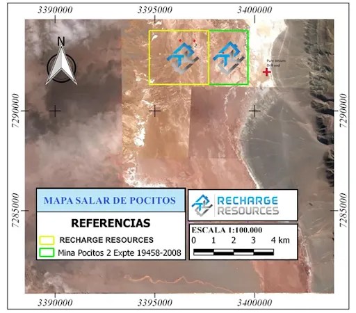
The Pocitos I exploration area is located in the Los Andes Department in Salta Province, Argentina. Located approximately 250km west of the provincial capital city of Salta, Pocitos I sits at 3,660m asl, approximately 10km from the township of Pocitos. Additional infrastructure exists in the Pocitos area including a gas pipeline, electricity, telephone internet services and rail service. The highway from Salta city to Pocitos is sealed.
The provincial capital city of Salta, Argentina is directly connected via well-maintained sealed and gravel roads to the city of Antofagasta, Chile, the most populated city in northern Chile and the largest sea port in the region.
Pocitos I is accessed from the provincial capital city of Salta via National Route RN-51, passing through the town of San Antonio de Los Cobres. The Salta-San Antonio route is more than 70% paved. At the junction of Provincial Route No. 27, in the vicinity of Cauchari, travel to the town of Estacion Salar de Pocitos where there are two routes to the Site via Provincial Route No. 17 (15km) and Provincial Route No. 27 (12km).
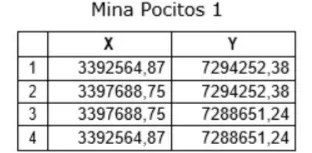
The area of the mines that make up this Project is defined by the following Gauss Kruger Postgar System coordinates.
The climate in the Pocitos I region is characteristic of high mountain environments. Weather is extremely dry and windy, with low temperatures and oxygen-poor air. The average annual rainfall decreases significantly from east to west and from north to south. Total rainfall in the region averages 70mm per year. During winter months, records indicate small quantities of snow and hail.